
The road to Igbokofi, a border community in Yewa North LGA of Ogun state, is not for the weak, especially during the rainy season. The narrow and dusty road has since given way to swamps and streams. The only means of transportation through the dangerous smuggling paths leading to the community is a motorcycle. At intervals, you may alight to push the motorcycle through a long stretch of slippery mud swamps. As soon as this reporter stepped into Igbokofi, which shares an international boundary with the Benin Republic, a neighbouring West African country, a text message popped up: “Y’ello, Welcome to Benin, you are roaming on MTN Benin.”
Igbokofi is at the centre of an identity crisis, but the residents say it is an ownership tussle. It belongs to Nigeria officially, but the Benin Republic is also battling for its soul. With a population of roughly 1000, the residents have accused the neighbouring country of land encroachment, intimidation and illegal arrest.
According to the residents, the only time they have a sense of belonging to Nigeria is during elections when politicians and electoral officials remember the nine polling units in the community. When the elections are over, the people return to their farms and the politicians to their cocoons. The Nigerian police post in the community has long been abandoned, the access roads are not motorable and the healthcare centre is non-functional.
One thing stands out between Igbokofi and the neighbouring Yoruba-speaking villages under the control of Benin Republic. While the latter have well-paved roads, quality telecommunication networks, electricity, good hospitals and other modern facilities, Igbokofi cannot boast of such. Yet, the residents don’t want to belong to the Francophone country owing to the “multiple taxes” they impose on them.
On August 14, 2021, the residents protested against “the illegal occupation of their land” by the Benin Republic. The protesters said the document containing the 1914 treaty between the British colonial government and France in the partition of the boundary between the two West African nations must be respected in settling the border dispute. While Nigeria was colonised by Britain, Benin Republic was a colony of France.
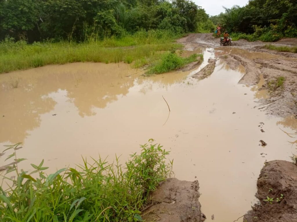
Road to Igbokofi
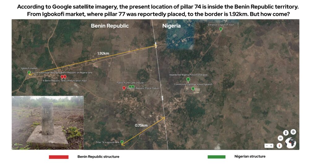
According to community members who spoke with TheCable, most of the pillars erected at the boundary to separate the two countries have been removed, except two: pillar 74 at Igbokofi and pillar 79 at Idigbo. Those said to be missing include pillars 75 at Lafenwa (now a part of Benin Republic), 76, 77 and 78 along Ibishi road. According to Igbokofi residents, the present location of pillar 74 is not where it was originally situated. They said it was uprooted from about 2,000 metres away and moved forward to its present position; while pillar 77, which was once behind Igbokofi market, has mysteriously disappeared.
“The removal of pillar 77 at the back of the market paved the way for the Beninoise government to begin its encroachment on our land,” Seke Aje, a community member, told TheCable.
“We were not aware of their plans initially, even when the pillars were disappearing. The reality dawned on us when Beninoise officials stormed our market one day to collect taxes.
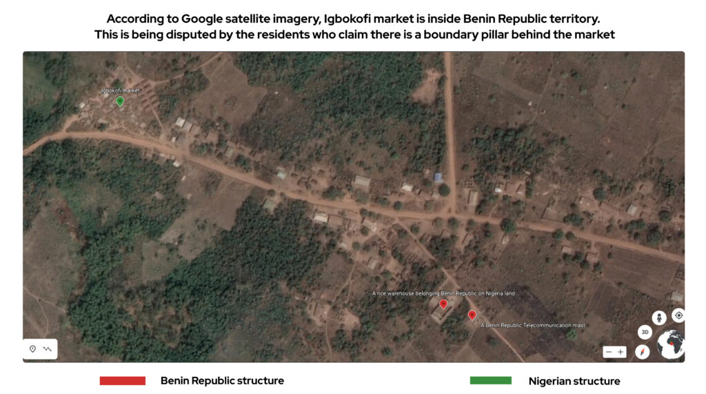
“We challenged them that the market belongs to Igbokofi and we are still part of Nigeria. But they said the area now belongs to them. We pointed to the pillar behind the market, but it was no longer there. This paved the way for the harassment of residents by Beninoise officials.”
Mathew Ajose, a 51-year-old resident of Igbokofi, was not so lucky during his encounter with Benin Republic security operatives known as gendarmes. His brush with the gendarmes at a forked path popularly called Asaga junction resulted in the loss of his sight.
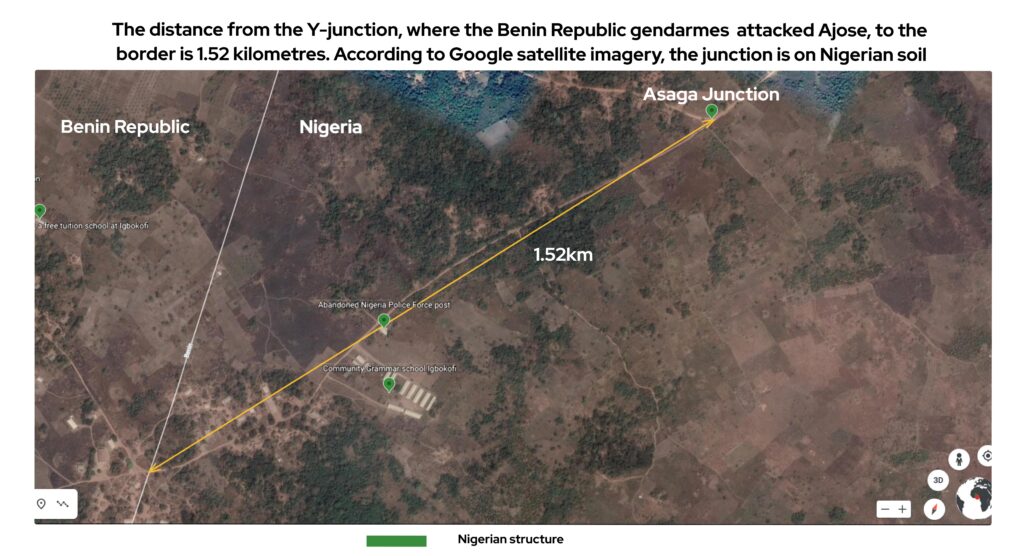
“I was carrying a load of timber from the forest to sell at Ogunba-Ayetoro when I met a barricade mounted by armed gendarmes at the junction before Igbokofi. They were issuing tickets to traders and they asked me for my licence. I was surprised why they stopped me because that place is part of Nigerian territory and they have no right to issue any licence to a timber trader,” Ajose said.
“I challenged them and they said that the place is part of the Benin Republic. As I was moving towards my vehicle to pick my phone and call my kinsmen, they pointed a gun at me. They called for reinforcement and other officers came to join them. They brought out a tear gas canister and sprayed it on my eyes. My face peeled. They used water to wash my teary face and that was how my journey to blindness began.”
Ajose was subsequently detained for one day at a police station built by the Benin Republic inside Igbokofi. He was later released after his elder brother paid N10,000 for his bail. According to him, his only offence was that “he trespassed”.
Ajose is now blind.
Despite having six children to fend for and put through school, Ajose can no longer visit his farm or sell timber. He now depends on financial support from community members, and his children to guide him everywhere.
‘THEY WANTED TO KILL ME’
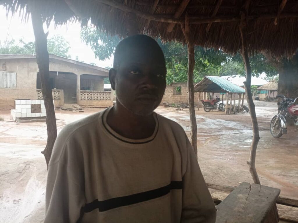
Kunle Garb, a missionary in Igbokofi, could have suffered a similar fate as Ajose after he was arrested by the gendarmes and sent to a prison in Porto Novo, capital of the Benin Republic, for 20 days. But providence smiled on him. He was accused of leading a protest against the neighbouring country on its soil. But Garb maintained that the protest against the alleged forceful takeover of the community happened on Nigerian soil.
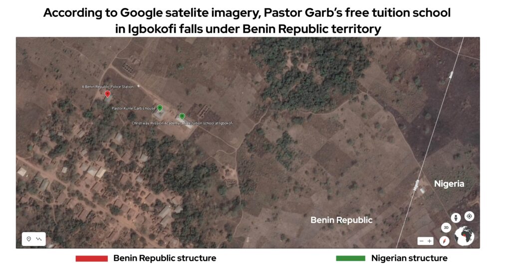
Without his walking stick, Garb limps from his house to the free-tuition school he built near the border. The harrowing experience at the small congested prison cell where he was confined with about 16 inmates has left his ankles disjointed.
“On June 24, I was at Igbokofi market when I was arrested by four gun-wielding gendarmes. Their plan was to kill me. They took me to their police station near my house and from there to Pobe. From there, I was arraigned in their court,” Garb told TheCable.
“Meanwhile, I was supposed to appear before the (Nigerian) national assembly on July 1 to intimate the lawmakers of the situation at Igbokofi and present the 1914 document which shows the clear boundary between the two countries. My arrest was part of the plan to stop that.
“During the court proceedings in the Benin Republic, I held on to the document as my evidence. Then, I asked the prosecutor to present the evidence that Igbokofi is owned by his country. He couldn’t present any. That was how I won the case. Till now, the Beninoise officials have not been able to provide any single document to prove their claim.”
Garb was released on July 13 at Pobe court and taken to Porto Novo to sign his release document around 8:15 pm. The motorcycle he boarded from Benin Republic broke down before reaching the border, hence he was forced to limp in the dark for 10 kilometres until he got home after midnight.
THE BOUNDARY POLITICS
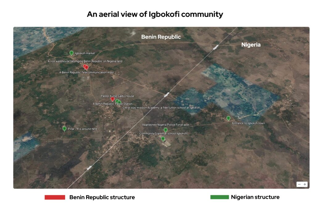 Aside from the police post built by the Benin Republic in Igbokofi, a mast belonging to a telecommunication company in the country was erected near the market and it is guarded by two gendarmes. Beside the mast is a big warehouse, and according to residents, there are about six warehouses in the community from where bags of foreign rice are allegedly smuggled into Nigeria. You’d also see solar light poles with flags of the Francophone country printed on them.
While officials of the neighbouring country collect taxes from traders, TheCable found that the Igbokofi market is registered under the market directory of Yewa North LGA. The authorities of Benin Republic were also alleged to have pulled down a Nigerian public school in Abojupa, a neighbouring village, and built another one in its name.
The Francophone country was said to have attempted to take over Tungeji Island, another border community in Ogun, but the Nigerian government reportedly fought back and reclaimed the island after it was discovered that it is rich in crude oil. The island of about a thousand residents now hosts a Nigerian naval base.
Despite the increasing presence and influence of the Benin Republic in Igbokofi, the residents keep fighting back — such that they now hoist Nigerian flags in front of their homes and farms.
An investigation of the international boundary line between Nigeria and the Benin Republic through Google Earth, an open-source app using satellite imagery, shows that Igbokofi is divided into two. The map allocates one half to Nigeria and the other to Benin Republic. But residents claim the community is one entity that cannot be divided between two countries. They also maintained that the Google satellite mapping of the community is incorrect as it is inconsistent with the pillars demarcating the boundaries.
For instance, the satellite mapping indicates that Asaga junction, where Ajose was tear-gassed, is inside Nigeria, but the gendarmes reportedly claimed he trespassed into their territory. The satellite image also indicates that the site of pillar 74 is over 0.75 kilometres from the border line and pillar 77 reportedly located behind the market is about 1.92 kilometres away from the boundary line. Both pillars are inside the Benin Republic territory.
“This is the basis through which they are encroaching on our land without following documentary evidence and the pillars. We are going to rely only on the 1914 document showing the boundary demarcation for this issue to be resolved,” Sunday Ogunyemi, a resident, said.
INVESTIGATING THE BORDER LINE A STEP FURTHER
But could the Google border mapping which the Benin Republic officials are reportedly using as a yardstick be wrong? Google Earth involves digital cartography in which data is collected and compiled using satellite imagery.
In 2010, faulty Google data bequeathed a portion of land belonging to Costa Rica, a Central American country, to neighbouring Nicaragua. The Nicaraguan government had referenced Google’s version of the boundary line as a reason to invade the disputed San Juan River border area. This led to a heated dispute between the two countries and eventually snowballed into an armed standoff.
Google was reported to have admitted its mistake and updated the map of the border line with an 1897 border treaty provided by the US Department of State.
Could the Google map demarcation of the border line between Nigeria and the Benin Republic at Igbokofi also be faulty? TheCable analysed three other open-source mapping tools to identify their versions of the demarcation.
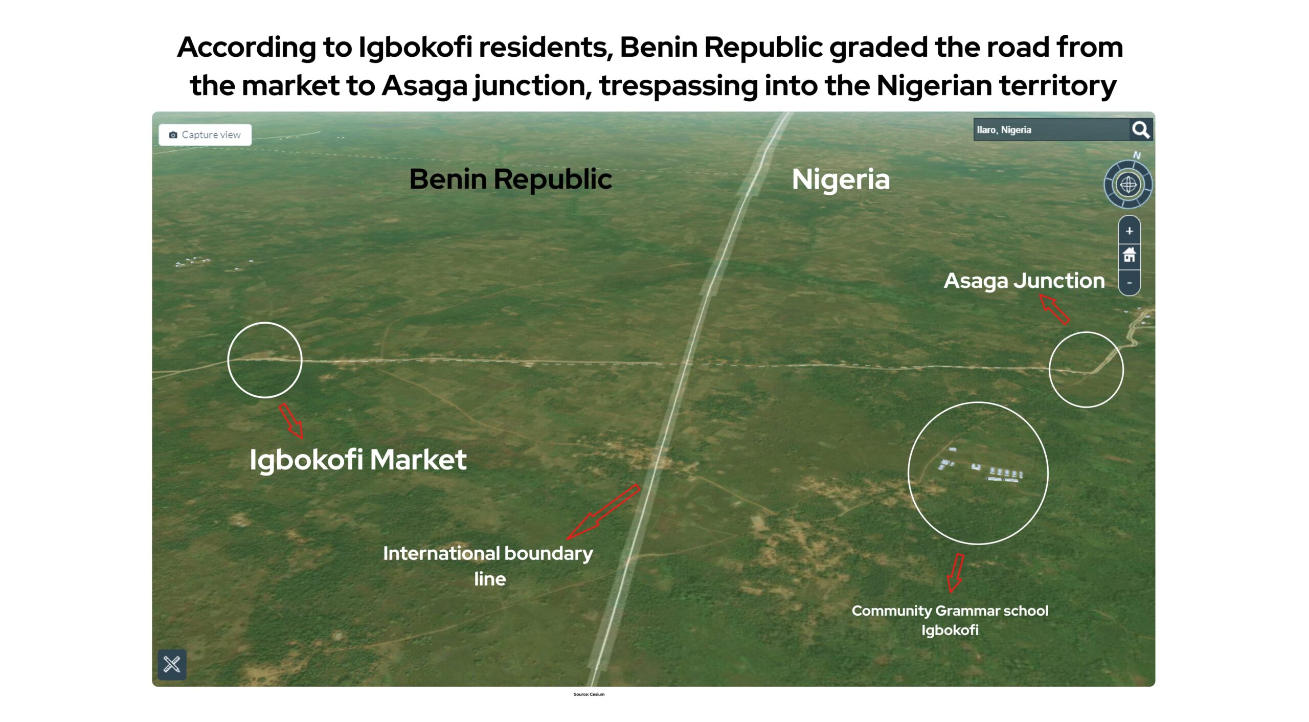
Using Cesium, an open-source 3D geospatial map, the international boundary line also divides Igbokofi into two halves — just like Google Earth. The market falls under the Benin Republic, while the secondary school stays in the Nigerian territory. This reporter was shown how the Benin Republic allegedly graded the road from Towe community in the country, towards the market to Asaga junction in Nigeria — a development which forced the residents to troop out to stop them.
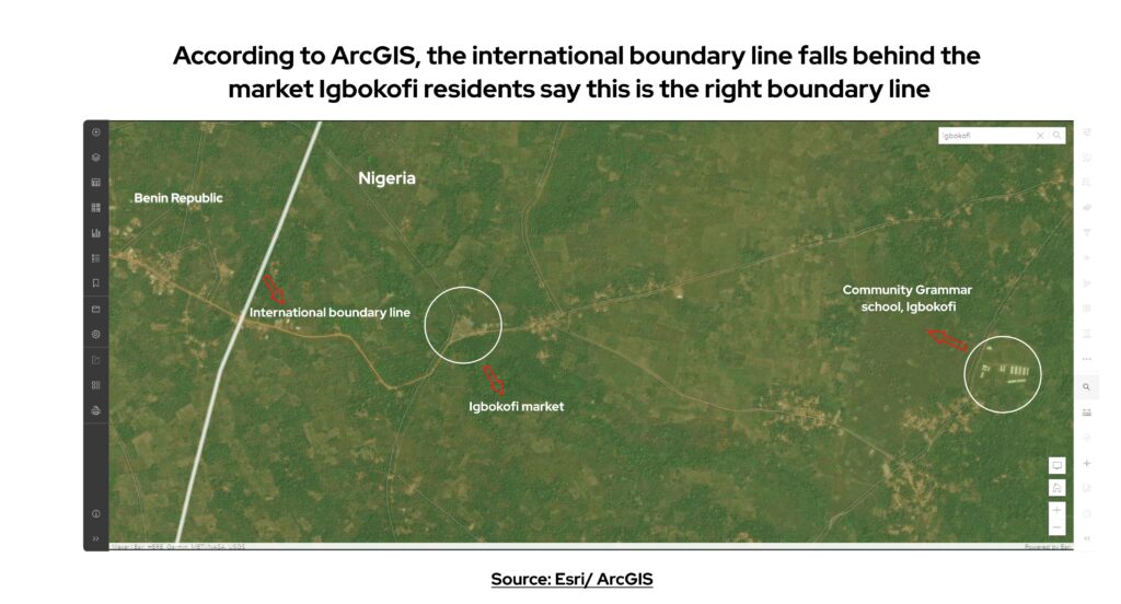
An analysis of ArcGIS, another web-based mapping software, gives a different view of Igbokofi. The international boundary line is behind the market, which the residents claim is the real boundary location. Here, the market and school are inside the Nigerian territory.
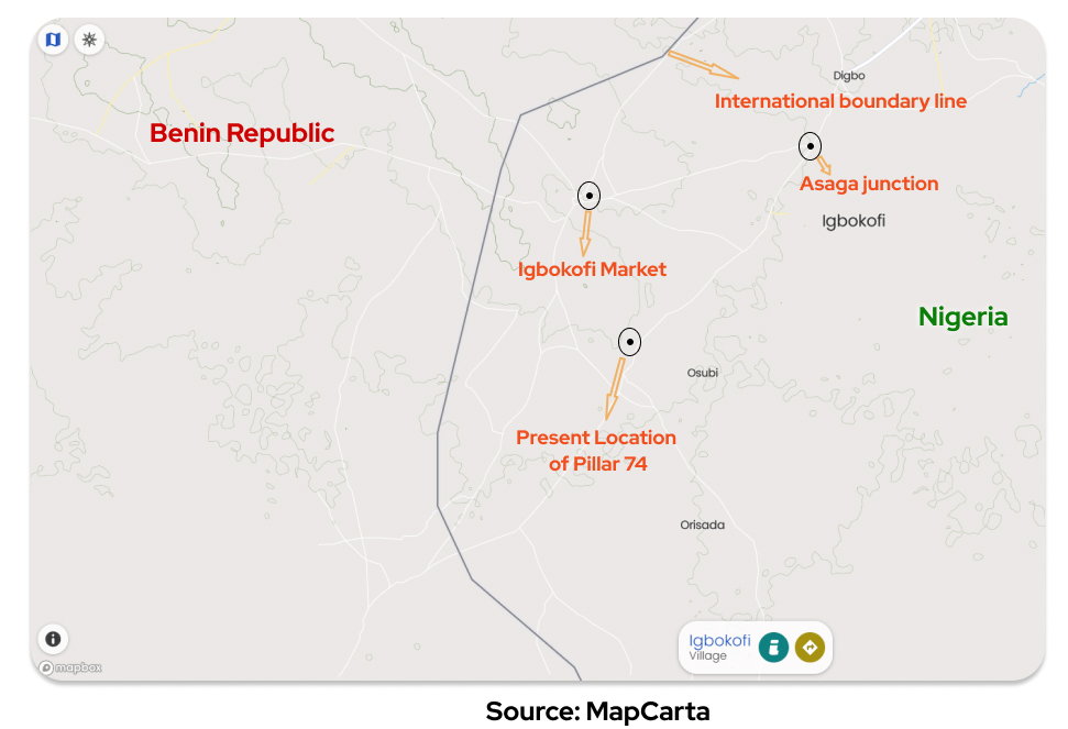
This is also supported by MapCarta, another open map software, which puts the boundary line behind the market.
 FG COMING TO THE RESCUE?
In a document obtained by TheCable, the traditional council of chiefs in the area wrote to the director of the National Boundary Commission that the ongoing adjustment of the border is not in accordance with the treaty agreement of 1914.
In the letter dated August 25, 2021, the residents said they still live in constant fear of attack by security operatives of the neighbouring country.
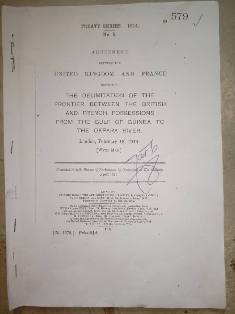
Frontpage of the 1914 document
“Consistently, at the sensitisation meeting in Ijoun on the 7th of August, 2021, the director generals of both Nigeria and Benin Republic boundary commission submitted that the 1914 treaty agreement will be used to locate the missing pillars of 75, 76, 77 and 78 and map out the boundaries,” the chiefs wrote.
“On Saturday 14th of August 2021, the technical team of both countries were at the pillar 74 and without tracing or attempting to trace the missing pillars of 75-78 made straight to pillar 79. On Monday 16th of August 2021, the technical team without Ogun State surveyors came to Igbokofi and worked on a straight line pillar 74-79 which is not in accordance with the treaty agreement of 1914 because pillars 74-79 can not be on a straight line.”
On November 13, five armed gendarmes visited the community again and allegedly harassed some residents who questioned their mission. While officials from different government agencies have visited Igbokofi to assure the people that the issue will be resolved, they still live in fear of intimidation by the gendarmes and Beninoise officials who visit the market every week to collect taxes.
Satellite imagery analysis by Samad Uthman
This is a special investigative project by Cable Newspaper Journalism Foundation (CNJF) in partnership with TheCable, supported by the MacArthur Foundation. Published materials are not views of the MacArthur Foundation.
Source: Policy Radar
No Comments to "INSIDE STORY: Ogun border community neglected by Nigeria — and now at mercy of Benin Republic"